Jul 02, 2009
The Suspicious Science Behind Man-Made Global Warming
By Dr. James Anderson, Minyanville
Paul Krugman, the Nobel Prize-winning economist, had an op-ed in Monday’s New York Times in which he called anyone who’s skeptical of man-made global warming a “traitor to the Earth.” Now, I don’t have a PhD in Economics (although I do have one in another field), nor do I have a Nobel Prize, but that accusation seems a bit over the top. Perhaps it’s just another example of the growing societal acrimony frequently discussed on Minyanville.
I’d like to take a look at the evidence for global warming resulting from increased CO2 levels in the atmosphere: The argument is that more infrared radiation released by the Earth is captured given the higher concentration of CO2 in the air, thereby warming the planet. However, if you’re looking for scientifically rigorous experiments linking CO2 to increased temperatures, I have bad news for you: It doesn’t exist.
What we have are computer models showing that increased CO2 levels will lead to catastrophic increases in global temperatures; an increase of as little as 10 degrees Fahrenheit will cause a lot of ice will melt, the sea level to rise, and Newfoundland to resemble Bermuda. But that’s the model talking.
Can any model accurately capture the complexities of the Earth’s atmosphere? There are certainly many sophisticated ones out there. Happily, most of them use actual physical experiments to verify their underlying assumptions. However, until the “Flux Capacitor” from Back to the Future gets built, any climate model will need decades to verify its assumptions using real data.
Climate simply refers to one day of weather after another. Global-warming true believers, let me ask you the following question: Do you view weather forecast projections for 2 weeks from today with the same certainty that you do a computer model that purports to predict the weather 100 years from now? If not, why not? After all, they’re both based on computer models. If your neighbor told you he were getting a tent for his daughter’s wedding reception 2 weeks from now, and you told him not to bother, because a computer model predicted sunny weather, do you think he’d take you seriously?
The key to good science—not good politics—is understanding the scientific method. Richard Feynmann, the Nobel Prize-winning physicist, put it this way: “It doesn’t matter how beautiful your theory is; it doesn’t matter how smart you are. If it doesn’t agree with experiment, it’s wrong.”
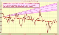
Since we can’t look 50 years into the future, let’s go back and look at the actual climate forecasts from 6 to 7 years ago, and compare the global temperature forecasts to the actual observed temperatures.
Here’s some science that no one with a vested political or financial interest in climate change would want you to know: The warmest year since 1934 was 1998, at the height of the strongest El Nino on record. The gold standard for CO2 measurement is taken at Mauna Loa Observatory in Hawaii. In 1998, the observatory recorded 366 parts per million (ppm) of CO2 in the atmosphere; it steadily rose to 386 ppm in 2008. In the meantime, the earth has cooled.
If we go back to climate models from, say, 2002, what did they predict during the past 7 years as CO2 was steadily rising?

Graph courtesy of SPPI enlarged here.
As you can see, the IPCC models—the ones blessed by the UN—predicted that global temperatures would be steadily warming, but instead they’ve been cooling. Let’s recall what Feynmann said: If the data don’t agree with the theory, the theory’s wrong—regardless of a widespread public desire to blame Exxon (XOM), or Chevron (CVX), or Hummers (GM) for global warming.
The observed temperature data don’t match what the model predicts. In physics (my field), we’d look at both the experiment and the data to see whether there was something wrong with the experiment’s design, or whether the data were right and the theory wrong. Either way, we’d step back and reevaluate everything. What we certainly wouldn’t do is cram 300 pages of amendments through Congress at 3:00 a.m. and force a vote the next day.
Back in March, 2007, Al Gore told Congress that “the science is settled.” Don’t do any more research, don’t question my judgment, “The science is settled.’ The person who probably heard that first was Galileo Galilei: “The science is settled. The Sun revolves around the Earth, not vice versa. You’re hereby sentenced to house arrest until you recant your heretical views.” Poor Galileo, the man Albert Einstein called “the father of modern science,” spent the rest of his life under house arrest. Read much more here.
Jun 30, 2009
Evidence for a solar signature in 20th-century temperature
By Jean-Louis Le Mouel, Vincent Courtillot, Elena Blanter, Mikhail Shnirman
We analyze temperature data from meteorological stations in the USA (six climatic regions, 153 stations), Europe (44 stations, considered as one climatic region) and Australia (preliminary, five stations). We select stations with long, homogeneous series of daily minimum temperatures (covering most of the 20th century, with few or no gaps).
We find that station data are well correlated over distances in the order of a thousand kilometres. When an average is calculated for each climatic region, we find well characterized mean curves with strong variability in the 3-15-year period range and a superimposed decadal to centennial or ‘secular’ trend consisting of a small number of linear segments separated by rather sharp changes in slope. Our overall curve for the USA rises sharply from 1910 to 1940, then decreases until 1980 and rises sharply again since then. The minima around 1920 and 1980 have similar values, and so do the maxima around 1935 and 2000; the range between minima and maxima is 1.38C. The European mean curve is quite different, and can be described as a step-like function with zero slope and a 1.8C jump occurring in less than two years around 1987. Also notable is a strong (cold) minimum in 1940. Both the USA and the European mean curves are rather different from the corresponding curves illustrated in the 2007 IPCC report.
We then estimate the long-term behaviour of the higher frequencies (disturbances) of the temperature series by calculating the mean-squared interannual variations or the ‘lifetime’ (i.e. the mean duration of temperature disturbances) of the data series. We find that the resulting curves correlate remarkably well at the longer periods, within and between regions. The secular trend of all of these curves is similar (an S-shaped pattern), with a rise from 1900 to 1950, a decrease from 1950 to 1975, and a subsequent (small) increase. This trend is the same as that found for a number of solar indices, such as sunspot number or magnetic field components in any observatory.
We conclude that significant solar forcing is present in temperature disturbances in the areas we analyzed and conjecture that this should be a global feature.
We have also shown that solar activity, as characterized by the mean-squared daily variation of a geomagnetic component (but equally by sunspot numbers or sunspot surface) modulates major features of climate. And this modulation is strong, much stronger than the one per mil variation in total solar
irradiance in the 1- to 11-year range: the interannual variation, which does amount to energy content, varies by a factor of two in Europe, the USA and Australia. This result could well be valid at the full continental scale if not worldwide. We have calculated the evolution of temperature disturbances, using either the mean-squared annual variation or the lifetime. When 22-year averaged variations are compared, the same features emerge, particularly a characteristic centennial trend (an S-shaped curve) consisting of a rise from 1920 to 1950, a decrease from 1950 to 1975 and a rise since. A very similar trend is found for solar indices. Both these longer-term variations, and decadal and sub-decadal, well-correlated features in lifetime result from the persistence of higher frequency phenomena that appear to be influenced by the Sun. The present preliminary study of course needs confirmation by including regions that have not yet been analyzed.

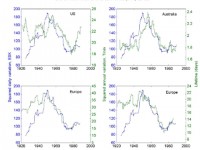
Larger version here. Comparison of the mean squared interannual variation (left column) and lifetime (right column) of the overall minimum temperature data from the US (153 stations), Australia (preliminary, 5 stations) and Europe (44 stations). Europe (bottom row) is shown for the two types of calculation for quick comparison (green curves), and also the magnetic index representing solar activity (blue curve).
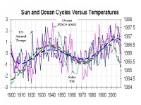
Icecap Note: Extending the solar TSI (Hoyt and Willson) and US temperatures up to the present time and adding the ocean multidecadal cycles, we see that relationship continue. It also suggest the current cooling trend as it is similar to the trend down in solar and ocean temperatures in the late 1950s and 1960s. Larger image here.

Jun 30, 2009
Obama’s ‘Climate Astrologer’ Chu Claims to the Ability to see Future out 100 Years
By Marc Morano, Climate Depot
President Obama’s Energy Secretary Steven Chu is at it again. Fresh off his declarations in May claiming computer model predictions as evidence of a certain climate catastrophe, (see: Climate Depot Exclusive: Sec. Chu’s assertions ‘quite simply being proven wrong by the latest climate data’ - April 19, 2009), he has now gotten more bold confidently predicts a certain climate catastrophe by the year 2109, when he and everyone who hears his warning today will be conveniently DEAD!

Obama’s Chief Astrologist Secretary Chu
Chu told a conference in California his latest prognostication. “At no other time in the history of science have we been able to say what the future will be 100 years from now,” Chu, the soothsayer, declared according to a June 28, 2009 article in Palo Alto Online News. The question looms: Shouldn’t Energy Sec. Chu be touting these scary predictions of the year 2100 on a boardwalk somewhere with a full deck of Tarot Cards?
Chu continued: “For the first time in human history, science has shown that we are altering the destiny of our planet...It’s quite alarming. Every year looks more alarming. ... An irony of climate change is that the ones who will be hurt the most are the innocent—those yet to be born.” Sec. Chu is exactly the reason many scientists are now reporting that man-made global warming fear promotion has degenerated to the level of astrology.
Japanese scientist Kanya Kusano, a Program Director and Group Leader for the Earth Simulator at the Japan Agency for Marine-Earth Science & Technology, has publicly declared that man-made climate fear promotion is now akin to “ancient astrology.” Mathematical physicist Frank J. Tipler, Professor of Mathematical Physics, astrophysics, at Tulane University, agrees with Kusano. “Whether the ice caps melt, or expand --- whatever happens --- the AGW theorists claim it confirms their theory. A perfect example of a pseudo-science like astrology,” Tipler wrote on May 15, 2009. “It is obvious that anthropogenic global warming is not science at all, because a scientific theory makes non-obvious predictions which are then compared with observations that the average person can check for himself,” Tipler explained. As we know from our own observations, AGW theory has spectacularly failed to do this. The theory has predicted steadily increasing global temperatures, and this has been refuted by experience. NOW the global warmers claim that the Earth will enter a cooling period,” Tipler wrote.
It is no wonder that the environmental movement is urging its troops to no longer use the term “global warming,” as temperatures fail to cooperate. (See: NYT obtains enviro strategy memo: Stop use of term global warming! )
Instead, climate change or “global weirding”—as New York Times columnist Thomas Friedman has proposed - are preferred. It is no wonder, that with climate change or “global weirding,” any weather event can now be linked to man-made global warming. Drought, flood, storms, tornado, hurricane? Simply more evidence of “global weirding.” Heatwaves, record cold, blizzards? Even more evidenced of “global weirding.” Therefore, anything that happens is further “proof” of man-made global warming.
After all, if every weather event that happens fits your global warming hypothesis or theory, the theory cannot be invalidated by real world observations or data. Climate fear promoters are now morphing to the level of the daily horoscope in your local newspaper. Horoscopes are worded in such a vague manner that essentially anything that happens to you that day can be touted as “proof” the horoscope was correct.
UK Professor Philip Stott has mocked today’s climate fears by comparing such fears to ancient civilizations. “From the Babylon of Gilgamesh to the post-Eden of Noah, every age has viewed climate change cataclysmically, as retribution for human greed and sinfulness,” Stott, an emeritus professor of Biogeography from the University of London wrote.
President Obama has also entered the “climate astrology” movement now. President Obama made the completely scientifically indefensible claim that the Waxman-Markey climate bill would stop global temperature increases of up to 5 degrees! Obama said on June 25, “A long-term benefit is we’re leaving a planet to our children that isn’t four or five degrees hotter.” How can the President of the U.S. can be so misinformed and full of such hubris that he somehow believes he can sign a bill that acts as a thermostat for Earth’s temperature?
President Obama seems so imbued with his ability to control climate that during the 2008 presidential campaign he prognosticated his presidency would be “the moment when the rise of the oceans began to slow and our planet began to heal.” (For latest scientific data refuting sea level rise fears see here.) President Obama has also claimed he can “block the Sun’s rays to end global warming.” Sadly, this has truly become the new age of “Climate Astrology.”
See full story and others here.
Jun 29, 2009
Climate Change Not a Security Threat: MOD Withdraws Climate Funding
By Olive Heffernan, Nature
The UK’s Met Office has had its funding for climate research slashed by a quarter, following withdrawal of financial support by the government’s Ministry of Defence (MoD).
The loss of 4.3 million pounds (US$7.0 million) in funding from the MoD will affect the Met Office Hadley Centre for Climate Change in Exeter, the world-class climate modelling institute whose researchers made key contributions to the last assessment report of the Intergovernmental Panel on Climate Change (IPCC) in 2007.
“This news comes as a shock,” says climate scientist Martin Parry, formerly at the Met Office and now at the Grantham Institute for Climate Change at Imperial College London. “The UK’s core modelling work on climate change has been funded from this source, up to now.”
“Global and regional security will be threatened by climate change, and the MoD is hopelessly wrong to think it is outside its responsibility,” adds Parry, who co-chaired the IPCC’s working group on climate impacts, adaptation and vulnerability.
In a statement, an MoD spokesperson said that the cuts, which will come into effect immediately, were made with a view to “prioritizing success in current operations, such as Afghanistan”.
On the defensive
This will be the first time that Met Office climate research has gone without MoD cash, according to a Met Office spokesman. The office became an executive agency of the ministry in 1990 and a commercialized trading fund in 1996. By 2008, one-sixth of its budget of 176.5 million pounds came from commercial services. But government, and the MoD in particular, has continued to be its main customer and funder.
In 2007, the MoD signed a three-year deal worth 12 million pounds with the Met Office, to part-fund its Integrated Climate Programme (ICP), which makes up the bulk of its climate research. Although the MoD has withdrawn its remaining funding, a Met Office spokesman insisted that the programme is not threatened.
The Department of the Environment, Food and Rural Affairs (DEFRA) is committed to providing 4 million pounds per year in funding up until 2011 to ICP, and the Department of Energy and Climate Change (DECC) will provide approximately 10 million pounds in annual funding over the same period.
The Met Office is now in negotiations with these departments, and with the Department for International Development (DfID), in an effort to recoup some of the lost funding.
“If they don’t recoup it, they are going to be in serious trouble,” said Gavin Schmidt, a climate modeller at NASA’s Goddard Institute of Space Studies in New York. “Losing 25% of your funding is a huge deal. Five percent is generally containable, but 25% is not an amount you can hope to absorb easily."…
Icecap Note: Let’s hope when American’s come to their senses and throw the bums out, the US follows suit with major cuts in funding for our national centers including NOAA’s NCDC (National Center for Data Corruption), NCAR (National Center for Astrological Research), NASA GISS and the Universities and national societies where most of the garbage science comes from thanks to major global warming research funding. When you pay someone generously to find a desired outcome, they deliver to keep the money coming. And, if the issue is really settled as they claim, then they have done their job and there is no need to do more. We can better invest that money elsewhere.
BTW, efforts are afoot in the UK to get the public back on the global warming bandwagon. The UK Met Office, reeling after embarrassing forecasts of hot summers the last two years (which were cool and wet) and warm winters (which were cold and snowy), is playing up a brief warm spell this week and Climate Change Secretary Ed Milbrand is having pamphlets warning of killer heat waves coming in the future unless we take action now to schools, libraries, health centres, hospitals and town halls across the country.
Meanwhile global temperatures continue the downslide now in its 8th year. Blue is UAH satellite MSU lower tropospheric data and Hadley CRUt3v (Hadley is used by (IPCC) versus the NOAA ESRL monthly seasonally adjusted CO2). Larger version here.

Jun 28, 2009
EPA May Have Suppressed Report Skeptical Of Global Warming
By Declan McCullagh, CBS News
The Environmental Protection Agency may have suppressed an internal report that was skeptical of claims about global warming, including whether carbon dioxide must be strictly regulated by the federal government, according to a series of newly disclosed e-mail messages. Less than two weeks before the agency formally submitted its pro-regulation recommendation to the White House, an EPA center director quashed a 98-page report that warned against making hasty “decisions based on a scientific hypothesis that does not appear to explain most of the available data.”
The EPA official, Al McGartland, said in an e-mail message to a staff researcher on March 17: “The administrator and the administration has decided to move forward… and your comments do not help the legal or policy case for this decision.” The e-mail correspondence raises questions about political interference in what was supposed to be a independent review process inside a federal agency—and echoes criticisms of the EPA under the Bush administration, which was accused of suppressing a pro-climate change document.
Alan Carlin, the primary author of the 98-page EPA report, told CBSNews.com in a telephone interview on Friday that his boss, McGartland, was being pressured himself. “It was his view that he either lost his job or he got me working on something else,” Carlin said. “That was obviously coming from higher levels.” E-mail messages released this week show that Carlin was ordered not to “have any direct communication” with anyone outside his small group at EPA on the topic of climate change, and was informed that his report would not be shared with the agency group working on the topic.
“I was told for probably the first time in I don’t know how many years exactly what I was to work on,” said Carlin, a 38-year veteran of the EPA. “And it was not to work on climate change.” One e-mail orders him to update a grants database instead. For its part, the EPA sent CBSNews.com an e-mailed statement saying: “Claims that this individuals opinions were not considered or studied are entirely false. This Administration and this EPA Administrator are fully committed to openness, transparency and science-based decision making. These principles were reflected throughout the development of the proposed endangerment finding, a process in which a broad array of voices were heard and an inter-agency review was conducted.”
Carlin has an undergraduate degree in physics from CalTech and a PhD in economics from MIT. His Web site lists papers about the environment and public policy dating back to 1964, spanning topics from pollution control to environmentally-responsible energy pricing. After reviewing the scientific literature that the EPA is relying on, Carlin said, he concluded that it was at least three years out of date and did not reflect the latest research. “My personal view is that there is not currently any reason to regulate (carbon dioxide),” he said. “There may be in the future. But global temperatures are roughly where they were in the mid-20th century. They’re not going up, and if anything they’re going down.”
Carlin’s report listed a number of recent developments he said the EPA did not consider, including that global temperatures have declined for 11 years; that new research predicts Atlantic hurricanes will be unaffected; that there’s “little evidence” that Greenland is shedding ice at expected levels; and that solar radiation has the largest single effect on the earth’s temperature.
If there is a need for the government to lower planetary temperatures, Carlin believes, other mechanisms would be cheaper and more effective than regulation of carbon dioxide. One paper he wrote says managing sea level rise or reducing solar radiation reaching the earth would be more cost-effective alternatives. The EPA’s possible suppression of Carlin’s report, which lists the EPA’s John Davidson as a co-author, could endanger any carbon dioxide regulations if they are eventually challenged in court.
“The big question is: there is this general rule that when an agency puts something out for public evidence and comment, it’s supposed to have the evidence supporting it and the evidence the other way,” said Sam Kazman, general counsel of the Competitive Enterprise Institute, a non-partisan think tank in Washington, D.C. that has been skeptical of new laws or regulations relating to global warming. Kazman’s group obtained the documents—both CEI and Carlin say he was not the source—and released the e-mails on Tuesday and the report on Friday. As a result of the disclosure, CEI has asked the EPA to re-open the comment period on the greenhouse gas regulatory proceeding, which ended on Tuesday.
The EPA also said in its statement: “The individual in question is not a scientist and was not part of the working group dealing with this issue. Nevertheless the document he submitted was reviewed by his peers and agency scientists, and information from that report was submitted by his manager to those responsible for developing the proposed endangerment finding. In fact, some ideas from that document are included and addressed in the endangerment finding.” That appears to conflict with an e-mail from McGartland in March, who said to Carlin, the report’s primary author: “I decided not to forward your comments… I can see only one impact of your comments given where we are in the process, and that would be a very negative impact on our office.” He also wrote to Carlin: “Please do not have any direct communication with anyone outside of (our group) on endangerment. There should be no meetings, e-mails, written statements, phone calls, etc.”
One reason why the process might have been highly charged politically is the unusual speed of the regulatory process. Lisa Jackson, the new EPA administrator, had said that she wanted her agency to reach a decision about regulating carbon dioxide under the Clean Air Act by April 2—the second anniversary of a related U.S. Supreme Court decision.
“All this goes back to a decision at a higher level that this was very urgent to get out, if possible yesterday,” Carlin said. “In the case of an ordinary regulation, these things normally take a year or two. In this case, it was a few weeks to get it out for public comment.” (Carlin said that he and other EPA staff members asked to respond to a draft only had four and a half days to do so.)
The revelations could prove embarrassing to Jackson, the EPA administrator, who said in January: “I will ensure EPAs efforts to address the environmental crises of today are rooted in three fundamental values: science-based policies and programs, adherence to the rule of law, and overwhelming transparency.” Similarly, Mr. Obama claimed that “the days of science taking a back seat to ideology are over… To undermine scientific integrity is to undermine our democracy. It is contrary to our way of life.” “All this talk from the president and (EPA administrator) Lisa Jackson about integrity, transparency, and increased EPA protection for whistleblowers—you’ve got a bouquet of ironies here,” said Kazman, the CEI attorney. Read full story here.
|
